
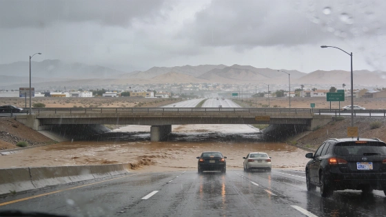
A flash flood warning covered Las Vegas and nearby communities Sunday. Rainfall reached as much as 3 inches in parts of the warned area, disrupting travel.
By 7:12 a.m. Sunday, radar estimates put rainfall at as much as 3 inches in parts of the warned area. Flooded lanes disrupted travel across the Las Vegas Valley, where multiple crashes were reported on major roads.
The National Weather Service warned that rapidly rising water could threaten motorists and pedestrians. Streets and highways were at risk, along with underpasses.
Transportation alerts cited flooding on Cheyenne Avenue and Sahara Avenue. The Regional Transportation Commission of Southern Nevada and Nevada Highway Patrol also listed collisions on valley roads and interstates. Authorities have not established that weather caused every crash.
Flooding closed all lanes of Interstate 15 near the Nevada-California border, according to the Regional Transportation Commission of Southern Nevada, as reported by NBC 26.
Flooding Shut Down Key Routes
The Regional Transportation Commission reported flooding on Cheyenne Avenue between Pecos Road and Las Vegas Boulevard. The water prompted an early transit detour. On eastbound Sahara Avenue near Interstate 15, flooding blocked two right lanes. NBC 26 also reported that floodwater left vehicles in difficulty and forced road closures. Early-morning rainfall exceeded 1 inch on the west side of the valley.
Crashes were listed on Interstate 11 and the Interstate 215 beltway. Others were reported on Rainbow Boulevard and Durango Drive. At about 7:23 a.m., a crash on northbound Rainbow Boulevard before Spring Valley Parkway blocked the right lane. Shortly after 7 a.m., a collision on southbound Durango Drive over Summerlin Parkway affected right lanes.
Other reported incidents included southbound I-215 before Lake Mead Boulevard and northbound I-11 over Rancho Drive. Another crash was listed on eastbound I-215 before I-11.
Nevada Highway Patrol records also listed accidents on Interstate 15 near Flamingo Road and Silverado Ranch Boulevard. An injury-related crash was reported near Lamb Boulevard in North Las Vegas. Investigators had not established the circumstances, including whether rain played a role. Records reviewed for this report did not establish the full extent of injuries or vehicle damage.
The National Weather Service linked the storm threat to a broad plume of tropical moisture associated with Isaias and Rachel, forecasting showers and thunderstorms with a risk of flash flooding across the Southwest. The agency extended its Flood Watch until 5 a.m. Monday, October 12, because runoff could affect low-lying areas, places with poor drainage and low-water crossings. By Monday morning, the heavy rain had stopped and floodwater had receded in affected areas, but the NWS advised caution because some roads remained closed.
Warning Covered Much of the Valley
The National Weather Service issued a flash flood warning for west-central Clark County at 5:33 a.m. Sunday. Radar indicated that about 0.75 to 1.5 inches of rain had fallen in parts of the warned area. An update at 7:12 a.m. put totals at about 1.5 to 3 inches. The NWS described the threat as potentially life-threatening. Urban areas and highways could be affected, along with streets and underpasses.
The warning included Las Vegas and North Las Vegas. Summerlin and Spring Valley were also covered, as were Paradise and Enterprise. The listed areas extended to Centennial Hills and the Las Vegas Strip. Fremont Street and areas near Harry Reid International Airport were included too.
Red Rock Canyon and Blue Diamond were named in the warning. So was Southern Highlands. Forecasters rated the flash-flood damage threat considerable and said water could collect in roads or drainage channels. Underpasses were also at risk. The warning was set to expire at 8:30 a.m., but that deadline did not mean flood hazards had ended.
The rain came with tropical moisture from the remnants of Tropical Storm Rachel. Las Vegas’s desert setting offers no protection from flash flooding: intense rain can run across paved surfaces and quickly collect in streets or low points. Conditions vary across the valley. A route that looks clear in one neighborhood may lead into standing water elsewhere.
Drivers Urged to Turn Around
The weather service warned motorists not to drive through floodwater. Its advice was to turn around and find another route. Water can hide damaged pavement or a washed-out road, and drivers may not be able to judge its depth from the surface.
Rain also cuts traction and visibility. Standing water can cause a vehicle to hydroplane. Slick pavement can make braking and steering less predictable. Slowing down and leaving more space between vehicles are practical precautions. Drivers should also avoid sudden maneuvers, and stay out of flooded roadways.
The disruption was separate from the scheduled Epique Realty Region 1 Power Summit at the Palms. For residents and visitors, Sunday’s immediate concern was getting through the valley while roads were flooded.
The reports do not prove that rain caused each collision. Available records also leave the full extent of injuries and vehicle damage unclear. By Monday morning, heavy rain had stopped and floodwater had receded in affected areas. The National Weather Service urged caution because some roads remained closed.